Whether the eruption of Santorini was the basis of the legend or not, this is a beautiful island with spectacular scenery.
photo link
Santorini
Rising from the blue waters of the Sea of Crete in the eastern Mediterranean, the picture-postcard multicoloured cliffs of Santorini (Thera, or Thira) belie their cataclysmic past. As your boat or plane approaches the island, it is a sobering thought that, the circular bay was once the heart of a volcano.
In around 1650 BC, a massive eruption emptied the chamber below the volcano of magma with such speed and force that the entire mountain collapsed into the void left behind. It is estimated that 30 cubic km (7 cubic mi) of magma must have been throw out to create a bay this size. The traces of previous eruptions can be seen in the coloured bands of rock on the island’s cliffs: each one is a layer of compressed ash ejected in one eruption. The little island in the middle of the bay is evidence of more recent volcanic activity, where a new volcano has formed in the heart of the old one.
photo link
It has long been thought that the eruption of Thera could be connected with Plato’s legend of the lost island of Atlantis, even though his land was located in the Atlantic Ocean. Evidence now suggests that he may have been relating a tale, corrupted over more than 1,200 years, of the destruction of the Minoan civilization on Crete by a tsunami created when the mountain collapsed. Whether the eruption of Santorini was the basis of the legend or not, this is a beautiful island with spectacular scenery.
What is it?
The remnants of a volcano.
How to Get There:
By boat from the Greek mainland or other Greek islands or by plane from Athens or Thessaloniki.
When to Go:
Spring to autumn.
Nearest Town:
Heraklion, Crete 123km (76 mi)
Don’t Miss:
The excavations at Akrotiri.
The Samaria Gorge
photo link
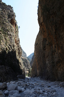
The Samaria Gorge is a spectacular geological feature in western Crete that is also important in the island’s history. It is Crete’s only national park. This gash in the White Mountains drops 1,250m (4,100ft) in 16km (10mi). For thousands of years, its secret tracks have provided a last hiding place, and secret base, for the locals to go when invaders strike. Today, its well trodden, if still tricky, path is a must-do for visitors to the island.
photo link
Most people get the bus from Chania to Omalos at the top of the gorge and then pick up a boat ride at Agia Roumeli to return to Chania. The first section of the trail is a steep descent of 1,000m (3,300ft) in less than 2km (1mi), down a feature known as the Wooden Stairs. The other 14km (9mi) is a relatively easy descent of 250m (800ft), and it is much easier to appreciate the spectacular scenery and wild flowers.
The old village of Samaria, half-way down the gorge, is also a good place to catch your breath and take in the delightful views, before making the final descent towards the Iron Gates, where the sides of the gorge narrow dramatically to leave a passage a mere 3m (10ft) across.Late spring, when the wild flowers are at their best, is the best time to undertake this hike: the gorge is not opened until the river has stopped flowing and in the height of summer, the heat in the gorge can be stifling. For this reason, an early start is a good idea, so that you spend as little of the four to seven hours the descent takes in the heat of the day.
What is it?
A spectacular 16-km (10-mi) gorge in the west of Crete.
How to Get There:
By bus from Chania to Omalos.
When to Go:
Late spring.
Nearest Town:
Omalos
Don’t Miss:
The views.
You Should Know:
It is advisable to take plenty of water and a snack or two.
Read full article:Natural Wonders of The World: Santorini and The Samaria Gorge,Greece
Natural Wonders of The World: Santorini and The Samaria Gorge, Greece
Info Post


0 comments:
Post a Comment